NGHỆ THUẬT
LÀM ĐẸP VÀ SỨC KHỎE
THỦ CÔNG
VĂN HÓA VÀ LỊCH SỬ
GIẢI TRÍ
MÔI TRƯỜNG
THỰC PHẨM VÀ ĐỒ UỐNG
KỸ THUẬT NGƯỢC
KHOA HỌC
THỂ THAO
CÔNG NGHỆ
THIẾT BỊ ĐEO
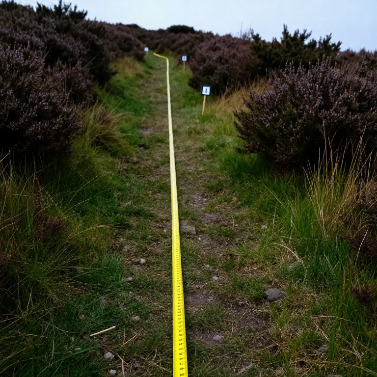


The Line Transect: Recording How a Community Changes
Random quadrats answer 'how much is there'. They are the wrong tool for 'how does it change as you walk from the stream to the hilltop', because scattering samples at random throws away the very ordering you are asking about.
A transect is a line laid deliberately ACROSS a gradient — a shoreline, a path edge, a slope, a woodland margin — with records taken at intervals along it. The result is a profile: which species give way to which, and where the change happens.
Zonation on a rocky shore is the classic example, and the same method reads a hedge bank, a trampled path, or the edge of a mulched bed. It is the cheapest way to turn 'the plants are different over there' into a diagram with distances on it.
Cơ bản
1 day
Hướng dẫn
1
1
Choose the line to cross the gradient squarely
Choose the line to cross the gradient squarely
Run the tape at right angles to whatever is changing — straight up the slope, straight out from the water, straight across the path — not along it.
A line laid along a contour samples one zone many times and tells you nothing about the sequence. Fix both ends with stakes and record a compass bearing, so the exact line can be re-laid next year. If the gradient is not obvious, walk it first and look before committing the tape.
Vật liệu cho bước này:
 Cọc gỗ4 cái
 Bộ cờ và cọc cắm khảo sát1 bộ
Công cụ cần thiết:
 Thước dây cuộn
 La bàn
 Búa nhổ đinh
2
2
Choose continuous, interrupted, or belt
Choose continuous, interrupted, or belt
A CONTINUOUS line transect records everything touching the tape. An INTERRUPTED one records only at fixed intervals — every metre, say. A BELT transect places a quadrat at each interval and records everything inside it.
Continuous is thorough and slow. Interrupted is fast and misses rare species between the points. Belt is the usual compromise and gives you quantities rather than presence alone. Choose deliberately and write down which you used, because the three are not comparable with one another.
Công cụ cần thiết:
 Sổ ghi thực địa
3
3
Record the physical gradient too
Record the physical gradient too
At every sampling point, record the physical variables as well as the species: height above the datum, soil pH, depth of litter, how wet the ground is, how much light reaches it.
Without them you have a description of a change and no candidate for its cause. With them you can plot species against the variable and see which one the distribution actually tracks — and often it is not the one you assumed. Levelling the line, using the method from the surveying batch, is what turns 'uphill' into metres.
Công cụ cần thiết:
 Giấy thử pH
 Thước kẻSổ ghi thực địa
4
4
Run more than one line
Run more than one line
Lay three or more parallel transects, separated by a sensible distance, rather than one very detailed line.
A single transect might have crossed a badger sett, an old bonfire site or a buried wall, and you would never know. Replicate lines let you tell a genuine gradient from a local accident — if all three show the same sequence, it is real. This is the commonest weakness in amateur transect work and it costs only time to fix.
Vật liệu cho bước này:
Cọc gỗ8 cáiCông cụ cần thiết:
Thước dây cuộnBúa nhổ đinh5
5
Plotting the profile and finding the boundaries
Plotting the profile and finding the boundaries
Đang tải sổ tay Jupyter…
Công cụ cần thiết:
 Giấy kẻ ô ly
6
6
Mark the ends so it can be repeated
Mark the ends so it can be repeated
Drive permanent markers at both ends, record their positions and the bearing, and photograph the line from each end.
A transect re-run in five or ten years is worth many times a single survey, because zonation MOVES — up a shore as sea level changes, out from a path as trampling changes, across a field as grazing changes. The photographs alone often show a change that the species list does not.
Vật liệu cho bước này:
Cọc gỗ4 cáiCông cụ cần thiết:
La bànSổ ghi thực địaBlueprint liên quan
Các blueprint này chia sẻ kiến thức — kỹ thuật, vật liệu hoặc nguyên tắc


CC0 Phạm vi công cộng
Bản thiết kế này được phát hành theo CC0. Bạn tự do sao chép, sửa đổi, phân phối và sử dụng cho bất kỳ mục đích nào mà không cần xin phép.
Hỗ trợ nhà sáng tạo bằng cách mua sản phẩm qua bản thiết kế, nơi họ nhận Hoa hồng nhà sáng tạo do nhà bán hàng đặt, hoặc tạo phiên bản mới và kết nối trong bản thiết kế riêng để chia sẻ doanh thu.