

Excavation Grid and Context Sheet
Digging destroys the thing it studies. Once a layer is removed it cannot be put back, so the only part of an excavation that survives is the record. An object with no record of where it came from tells you almost nothing; a well-recorded empty layer can tell you a great deal.
Two tools carry that record. A grid tied to a fixed datum gives every find a position in three dimensions that can still be plotted a century later. A context sheet — one per deposit, cut or layer — records what that unit was, what it lay above and below, and what came out of it.
Build a site in a box, bury a sequence, then excavate it properly. The test at the end is whether someone who never saw your box can reconstruct the order of events from your paperwork alone.
নির্দেশ
Build the practice site in layers
Build the practice site in layers
In a shallow box, lay down sand, then a thin layer of dark soil, then more sand, burying different objects in each. Have someone else build it so the excavator does not know the answer.
এই ধাপের উপকরণ:
 Quartz Sand5 কেজি
Cut a feature into the layers
Cut a feature into the layers
Before the top layer goes on, dig a small pit through the layers below and fill it with a different material. That pit is a cut and its filling is a fill — two separate contexts, and the pair that teaches the whole idea.
Fix a datum point
Fix a datum point
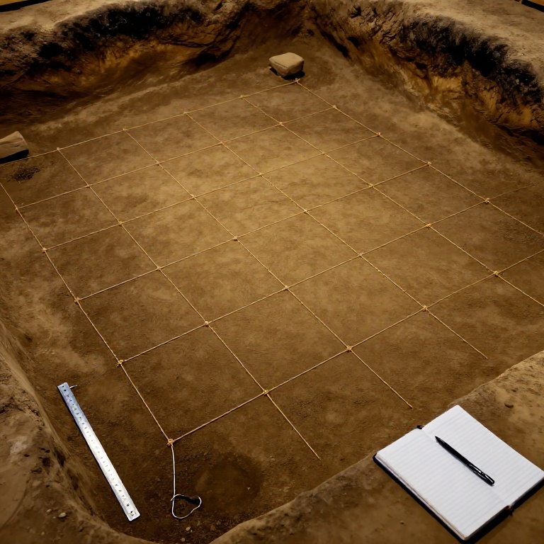
Fix one permanent marker at a corner and call it the datum. Every measurement on the site is taken from it. If the datum moves, the entire record becomes fiction.
Lay a squared grid over the site
Lay a squared grid over the site
Run string in both directions from the datum to make squares of a fixed size — 100 mm squares suit a box, 1 m squares a real trench. Check the diagonals are equal so the grid is square, not a parallelogram.
এই ধাপের উপকরণ:
 Cotton Thread5 মিটার
আবশ্যক উপকরণ:
 Measuring Ruler
Label the grid squares
Label the grid squares
Letter one axis and number the other, so every square has a unique reference like C4. Two coordinates plus a depth give any find a position in three dimensions.
Photograph the site before you touch it
Photograph the site before you touch it
Photograph the surface with a scale and a north arrow in frame. This is the last moment the site exists intact.
Excavate the youngest layer first
Excavate the youngest layer first
Remove the topmost deposit and nothing else, working with a trowel drawn toward you in even strokes. Layers come off in the reverse of the order they went down — that reversal is the law of superposition doing your dating for you.
আবশ্যক উপকরণ:
 Trowel
Give each context its own number
Give each context its own number
Number every deposit, cut and fill in the order you meet it: 001, 002, 003. A context number is never reused and never renamed, because every other record points at it.
Fill in a context sheet before removing it
Fill in a context sheet before removing it
For each context record: number, type (deposit, cut or fill), colour, texture, inclusions, thickness, its grid extent, and what it physically touches. Write the sheet while the context is still there to look at.
আবশ্যক উপকরণ:
 Record-Keeping Notebook
Record the stratigraphic relationships
Record the stratigraphic relationships
On each sheet write what this context is above, what it is below, and what it cuts or is cut by. These three relations are what turn a pile of sheets into a sequence.
Bag finds by context, not by object
Bag finds by context, not by object
Everything from one context goes in one bag labelled with that context number. An unlabelled find is a souvenir; a labelled one is evidence.
Plot anything significant on the grid
Plot anything significant on the grid
Draw notable finds onto a squared plan with their grid square and depth below datum. Position within a context can matter as much as the context itself.
Photograph and draw a section
Photograph and draw a section
Leave one wall of the box undug to the end and draw it in profile with all the layers labelled by context number. The section is the visible proof of the sequence your sheets describe.
Build the Harris matrix
Build the Harris matrix
Turn the relationships into a diagram: each context a box, lines running from later down to earlier. Contexts with no relationship sit side by side. The finished matrix is the site's chronology stripped of everything else.
Date the fill against what it cuts
Date the fill against what it cuts
Read off the matrix: the fill of a pit must be younger than every layer the pit cuts through. That single deduction — which nothing in the objects themselves tells you — is what stratigraphy is for.
Test the record on someone else
Test the record on someone else
Hand your sheets, plans and matrix to the person who built the box and ask them to check the order you reconstructed. Anything you got wrong points at a field you left blank.
Compendium — why it is done this way
Compendium — why it is done this way
Single context recording. The system of giving every deposit, cut and fill its own number and its own sheet was developed by Edward Harris and Patrick Ottaway in 1976, from a suggestion by Laurence Keen, and was worked into a full field method by the Department of Urban Archaeology at the Museum of London. It spread from there in the mid-1980s to Scotland and York and then far more widely. It suits deep, complicated urban sites where dozens of contexts can overlap in a few square metres.
Why one sheet per context. Because the alternative — describing a trench as a whole — hides the joins. Recording each unit separately forces the excavator to decide where one deposit ends and the next begins, in the field, while the evidence is still visible. It also means two people digging different parts of a site produce records that combine without translation.
The Harris matrix. Harris's diagram shows only stratigraphic relationships — earlier, later, or no relationship — and deliberately throws away everything else. That austerity is the point: it separates the sequence, which is observed, from the interpretation, which is argued. You can disagree about what a pit was for and still agree about when it was dug.
What a context sheet cannot hold. Field recording always involves interpretation — deciding that two patches of soil are one deposit or two is a judgement, made once, by one person, and it is not recoverable later. Researchers who have gone back through archived context sheets find exactly that: the primary record contains interpretation as well as observation. Good practice is to write what you saw and what you concluded as separate statements, so a later reader can tell them apart.
The rule that follows from all of it. Excavation is the only science that destroys its own evidence as it collects it. There is no repeating the experiment. That is why the paperwork is not bureaucracy around the dig — it is the dig, and the hole in the ground is the by-product.
সামগ্রী
2- 5 কেজিপ্লেসহোল্ডর
- 5 মিটারপ্লেসহোল্ডর
আবশ্যক উপকরণ
3- প্লেসহোল্ডর
- প্লেসহোল্ডর
- প্লেসহোল্ডর
সম্পর্কিত ব্লুপ্রিন্ট
এই ব্লুপ্রিন্টগুলি জ্ঞান ভাগ করে — কৌশল, উপকরণ বা নীতি
CC0 পব্লিক ডোমেন
এই ব্লুপ্রিন্ট CC0-এর অধীনে প্রকাশিত। আপনি অনুমতি ছাড়াই যেকোনো উদ্দেশ্যে এটি অনুলিপি, পরিবর্তন, বিতরণ ও ব্যবহার করতে পারেন।
মেকারের ব্লুপ্রিন্টের মাধ্যমে পণ্য কিনে তাঁকে সমর্থন করুন, যেখানে তিনি আয় করেন মেকর কমীশন বিক্রেতাদের নির্ধারিত, অথবা এই ব্লুপ্রিন্টের একটি নতুন সংস্করণ তৈরি করে নিজের ব্লুপ্রিন্টে সংযোগ হিসেবে যুক্ত করে আয় ভাগ করুন।