ART
BEAUTY & WELLNESS
CRAFT
CULTURE & HISTORY
ENTERTAINMENT
ENVIRONMENT
FOOD & DRINKS
REVERSE ENGINEERING
SCIENCES
SPORTS
TECHNOLOGY
WEARABLES
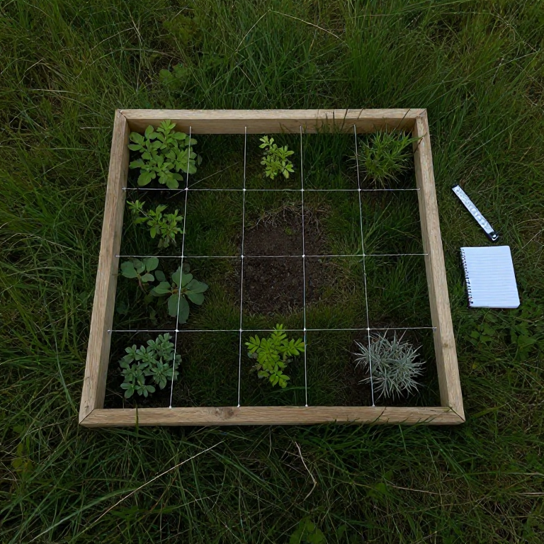


The Quadrat: Counting Plants Without Counting Them All
You cannot count every plant in a field, and you do not need to. Drop a frame of known area on the ground, count what is inside it, repeat enough times in the right places, and arithmetic does the rest.
The quadrat is the oldest and most useful tool in field ecology, and almost everything that goes wrong with it goes wrong before any counting starts — in WHERE the frames are placed. A person choosing spots that 'look representative' produces numbers that describe their own judgement, not the field, and no amount of careful counting afterwards recovers from it.
So this blueprint is mostly about randomisation, replication and honesty about what a sample can support. Those three ideas are the whole of quantitative field biology, and they are worth learning on a lawn before anything depends on them.
Beginner
1 day
Instructions
1
1
Make a frame of a known, stated area
Make a frame of a known, stated area
Build a rigid square frame of a size that suits your subject — 0.25 m by 0.25 m for moss, 0.5 m for grassland, 1 m or more for shrubs — and write its INTERNAL dimensions on it.
Measure and record the inside, not the outside: a frame of 25 mm timber has an outside area 20 per cent larger than its inside, and mixing the two silently inflates or deflates every density you ever calculate. Stringing it into a grid of 25 or 100 small squares makes percentage cover far quicker to estimate.
Materials for this step:
 Wooden Dowel4 pieces
 Galvanized Nails12 pieces
Tools needed:
 Hand Saw
 Measuring Tape
 Permanent Marker
 String Line
2
2
Place it at RANDOM, and mean random
Place it at RANDOM, and mean random
Lay two tapes at right angles along the edges of your area to make a coordinate grid, generate pairs of random numbers, and place the frame where each pair falls — including when that is a bare patch or an awkward corner.
Throwing the quadrat over your shoulder is not random: it lands further on open ground than in a thicket, and people throw harder when they are bored. Moving a frame 'because it landed on the path' biases the result by exactly the amount the path matters. If the path is in your area, it is part of your answer.
Tools needed:
Measuring Tape Field Notebook
3
3
Decide your rules before you look
Decide your rules before you look
Write down, in advance: does a plant rooted outside but overhanging count? What about one rooted exactly on the line? Are you recording DENSITY (how many), FREQUENCY (in how many quadrats it appears) or COVER (what fraction of ground)?
Deciding these while looking at a difficult plant is how a result bends toward the answer you expected. The usual conventions are: count it if it is ROOTED inside, and count a plant on the line if it is on the north or east edge only. Any rule works; an unwritten rule does not.
Tools needed:
Field Notebook Magnifying Glass
4
4
Estimate cover consistently, and check yourself
Estimate cover consistently, and check yourself
For percentage cover, use the strung grid and count squares. Then have a second person estimate the same quadrat independently and compare.
Cover estimates by eye are notoriously variable between observers — differences of twenty percentage points on the same quadrat are common — and the difference between your two estimates IS your measurement error. If you must work alone, re-estimate a few quadrats an hour later without looking at your first answer.
Tools needed:
Field Notebook5
5
How many quadrats, and what the number means
How many quadrats, and what the number means
Loading Jupyter Notebook...
Tools needed:
Field Notebook6
6
Record enough that someone else could repeat it
Record enough that someone else could repeat it
Note the date, the site, the grid you used, the quadrat size, the rules from step 3, who recorded, and the weather.
An ecological survey is only worth anything if it can be repeated in five years to see what changed, and that repeat has to use the same method or the comparison is meaningless. Mark at least two corners of your grid permanently so the same area can be found again — that single act turns a survey into a monitoring programme.
Materials for this step:
 Wooden Stake4 pieces
Tools needed:
 Claw Hammer
 CompassField Notebook
 Survey Flags and Pin Kit
Materials
3- 4 piecesPlaceholder
- 12 piecesPlaceholder
- 4 piecesPlaceholder
Tools Required
9- Placeholder
- 1 vendor sell this, none ship to you yetPlaceholder
- Placeholder
- Placeholder
- Placeholder
- Placeholder
- Placeholder
- Placeholder
- Placeholder
This blueprint makes

Related Blueprints
These blueprints share knowledge with this one — techniques, materials, or principles that connect them in the learning graph.



CC0 Public Domain
This blueprint is released under CC0. You are free to copy, modify, distribute, and use this work for any purpose, without asking permission.
Support the Maker by purchasing products through their Blueprint where they earn a Maker Commission set by Vendors, or create a new iteration of this Blueprint and include it as a connection in your own Blueprint to share revenue.